Juneau Coordination Transportation Coalition
Get Around Juneau
Ride the Bus
Capital Transit
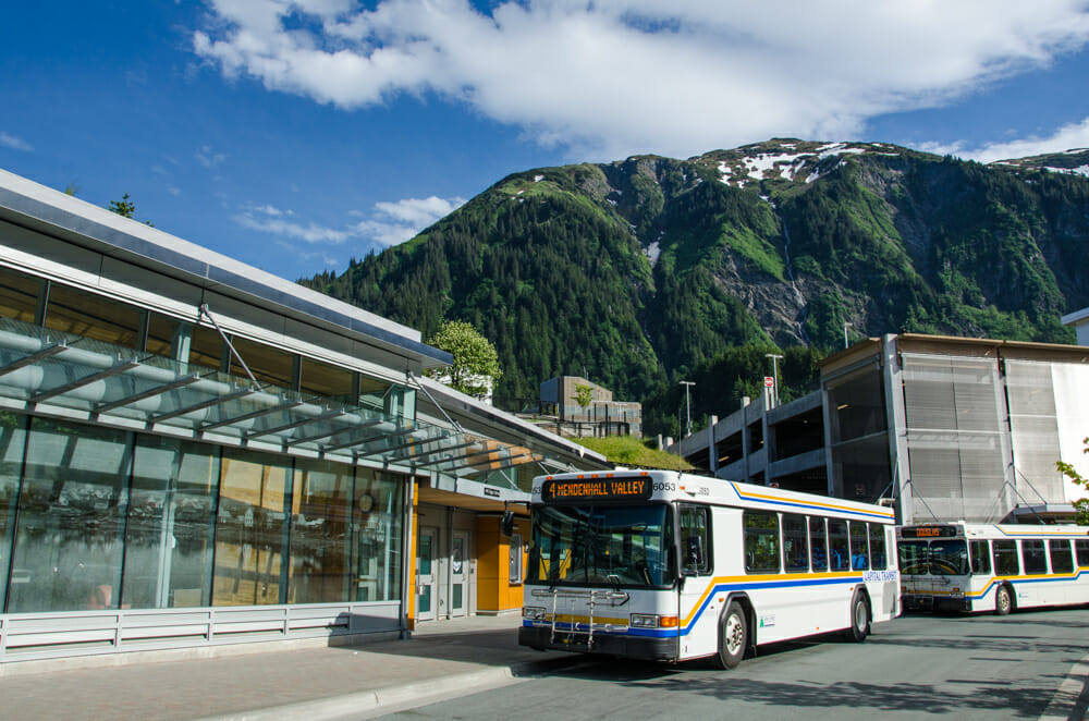 Capital Transit is the public transportation provider for the community of the City and Borough of Juneau. They provide a fixed route bus service on three routes with ridership of over 1.25 million passenger trips annually. They also provide paratransit service to persons who cannot use the bus service with Care-A-Van provided by contract with Catholic Community Services. Capital Transit has been upgrading its bus lines and now nearly all buses are wheelchair accessible. All buses can lower themselves to curb level allowing not only wheelchair access, but also making it much easier for any ambulatory person old or young to board the bus. Capital Transit also offers a VIP Pass that qualifies anyone with a significant disability to ride the bus system free of charge. The VIP Pass has made it possible for many Juneau residents to obtain and maintain competitive employment, which has in turned allowed them to live independently.
- Trip Planner, Routes and Schedules
- Fares and Passes
- VIP Bus Pass – Available to anyone with a significant disability for riding the bus system free of charge.
- Tax Exemption for Seniors – City & Borough Tax Exempt Form
Juneau School Bus
Eaglecrest Ski Bus
- Eaglecrest bus schedule
- For passengers with disabilities – Accessible rides to Eaglecrest are avaiable for passengers with disabilities. There is a fee for service. Visit Southeast Alaska Independent Living (SAIL) website
Catch a Cab
SAIL Taxi Vouchers for persons with disabilities
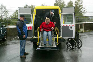 Last minute trips, as well as trips outside of public transit’s service area and hours, are a bit more affordable with our Taxi Voucher Program. SAIL and Juneau Taxi have joined forces through government grants for this very popular program allowing people 60 or older, or those with disabilities, to ride for 40 cents on the dollar.
An eligible person must simply complete a short application to be able to purchase fares at this discounted rate. This can be done at the Juneau office: 3225 Hospital Drive, Suite 100. Discounted rates can be used only with Juneau Taxi, they are good for anywhere on the Juneau road system and include use of the wheelchair accessible taxi.
- Contact SAIL 907-586-4920
- SAIL Website
- Taxi Voucher Intake Form
Taxi Services in Juneau
Get to Juneau
Alaska Marine Highway
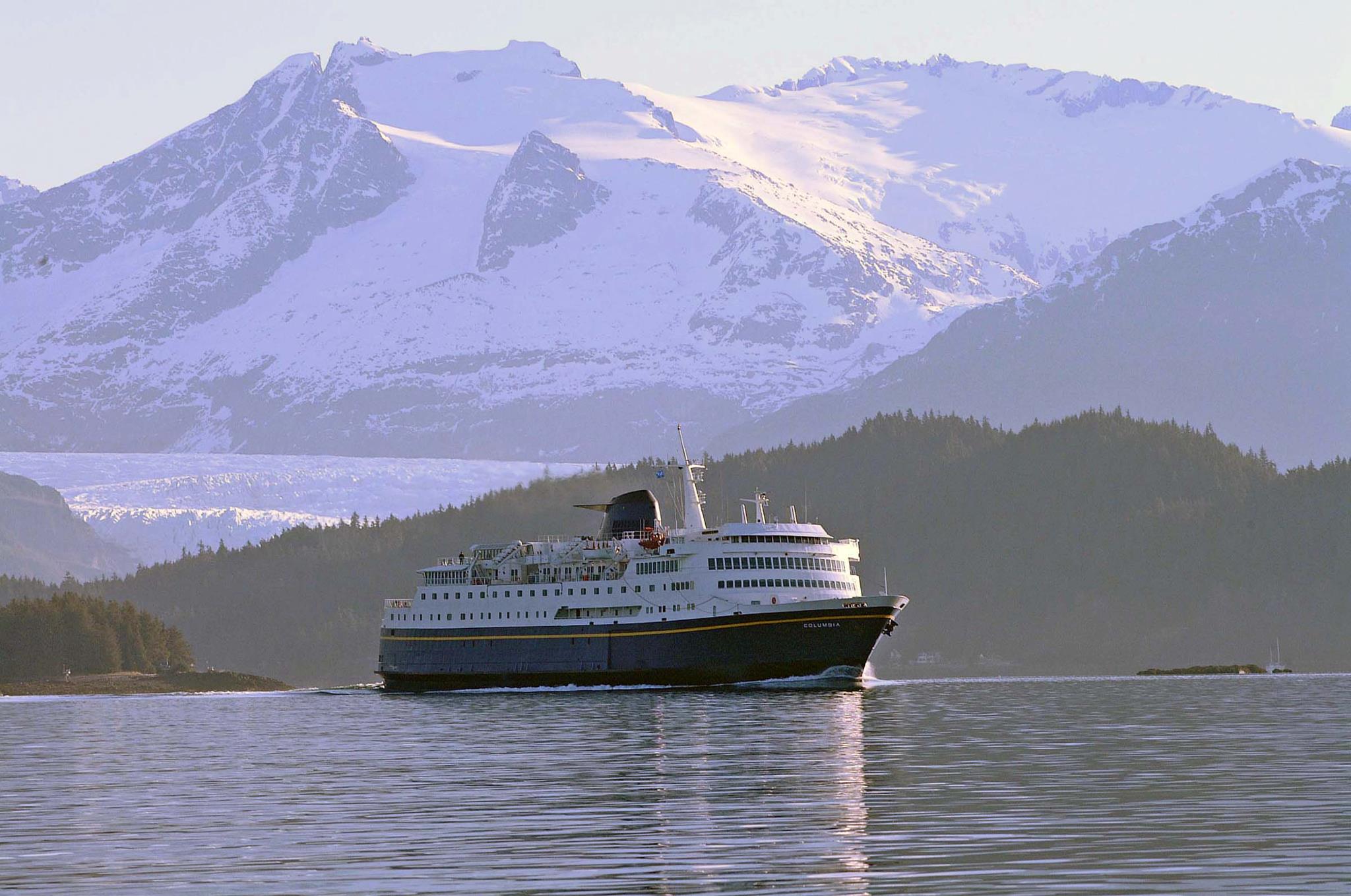 The mission of the Alaska Marine Highway System is to provide safe, reliable, and efficient transportation of people, goods, and vehicles among Alaska communities, Canada, and the “Lower 48,” while providing opportunities to develop and maintain a reasonable standard of living and high quality of life, including social, education, and health needs.
The Alaska Marine Highway System has been operating year-round since 1963, with regularly scheduled passenger and vehicle service to 33 communities in Alaska, plus Bellingham, Washington, and Prince Rupert, British Columbia. There are currently eleven vessels in the AMHS fleet, additional ferries have been planned.
Juneau Terminal location
13.5 mile Glacier Highway
Auke Bay, AK
- Contact the Juneau terminal – 907-465-8853
- Contact Alaska Marine Highway
- Alaska Marine Highway website
- Online reservations
- Making Connections
- For passengers with disabilities
- Senior fares
Juneau International Airport
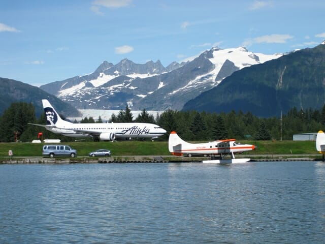 Juneau International Airport (JNU) is a city owned, public use airport and seaplane base located 8 miles northwest of the central business district of Juneau. The airport serves as a regional hub for all air travel, both bush carriers and the regional airline, Alaska Airlines.
1873 Shell Simmons Dr., Ste. 200
Juneau, AK 99801
- Contact Juneau International Airport – 907-789-7821
- Juneau International Airport website
- Passenger services
- For passengers with disabilities
- Transportation from the airport
- Airport parking
Visitors with Disabilities
Southeast Alaska Independent Living (SAIL) provides information and services for visitors to Juneau and Alaska’s Inside Passage who experience:
- Mobility restrictions such as needing occasional or full time use of a wheelchair or walker
- Visual impairments, including travel with a service dog
- Hearing impairments, including desire for interpretive services
- SAIL Accessible Travel in Alaska
Alaska Airlines
Daily jet service offers the quickest, easiest access to Juneau. Alaska Airlines is the only jet service provider to Juneau and offers daily connections north from Seattle and south from Anchorage. Jet service is also available from Juneau to other southeast communities, including Gustavus, Sitka, Wrangell, Petersburg, and Ketchikan.
- Contact Alaska Airlines – 800-252-7522.
- Alaska Airlines website
- Reservations
- For passengers with disabilities
All Airlines Serving Southeast
Bike
Biking Around Juneau
Juneau boasts an impressive 88 miles of bike lanes and 19 miles of shared-use paths. The city’s adoption of the 2009 Non-Motorized Transportation Plan helped the Alaska Department of Transportation improve bicycle facilities and create a Safe Routes To School plan for all Juneau elementary and middle schools.
In 2011, the League of American Bicyclists designated Juneau a Bicycle Friendly Community.
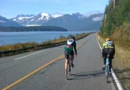
Photo Credit: Ben Lyman
Google Maps provides bicycling directions suggested routes.
City & Borough of Juneau Bike Maps
No entries match your request.
Additional Biking Information
Information about Biking Through Intersections
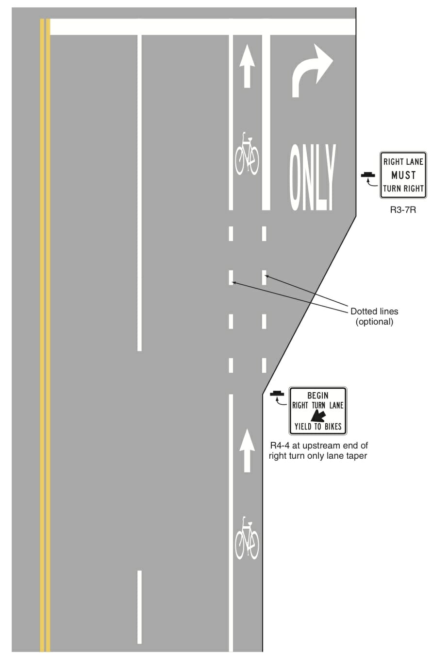
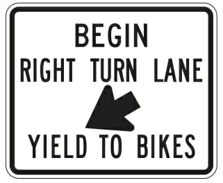 Right Turn Only Lanes and Bike Lanes
- Location(s):
- Glacier Highway at Anka Street in Lemon Creek
- (coming soon) Riverside Drive at Mendenhall Mall Road and Vintage Boulevard
There is one location in Juneau where a bike lane crosses the entrance to a right turn only lane: on Glacier Highway at Anka Street in Lemon Creek. The Department of Transportation and Public Facilities has plans to re-stripe where Riverside Drive intersects Mendenhall Mall Road and Vintage Boulevard. The design pictured below is the national standard and its use will increase in coming years until all bike lanes are striped this way at intersections.
When entering this right turn only lane, it is the responsibility of motorists to yield to any bicyclists that are proceeding through the intersection.
Walk
Walking Around Juneau
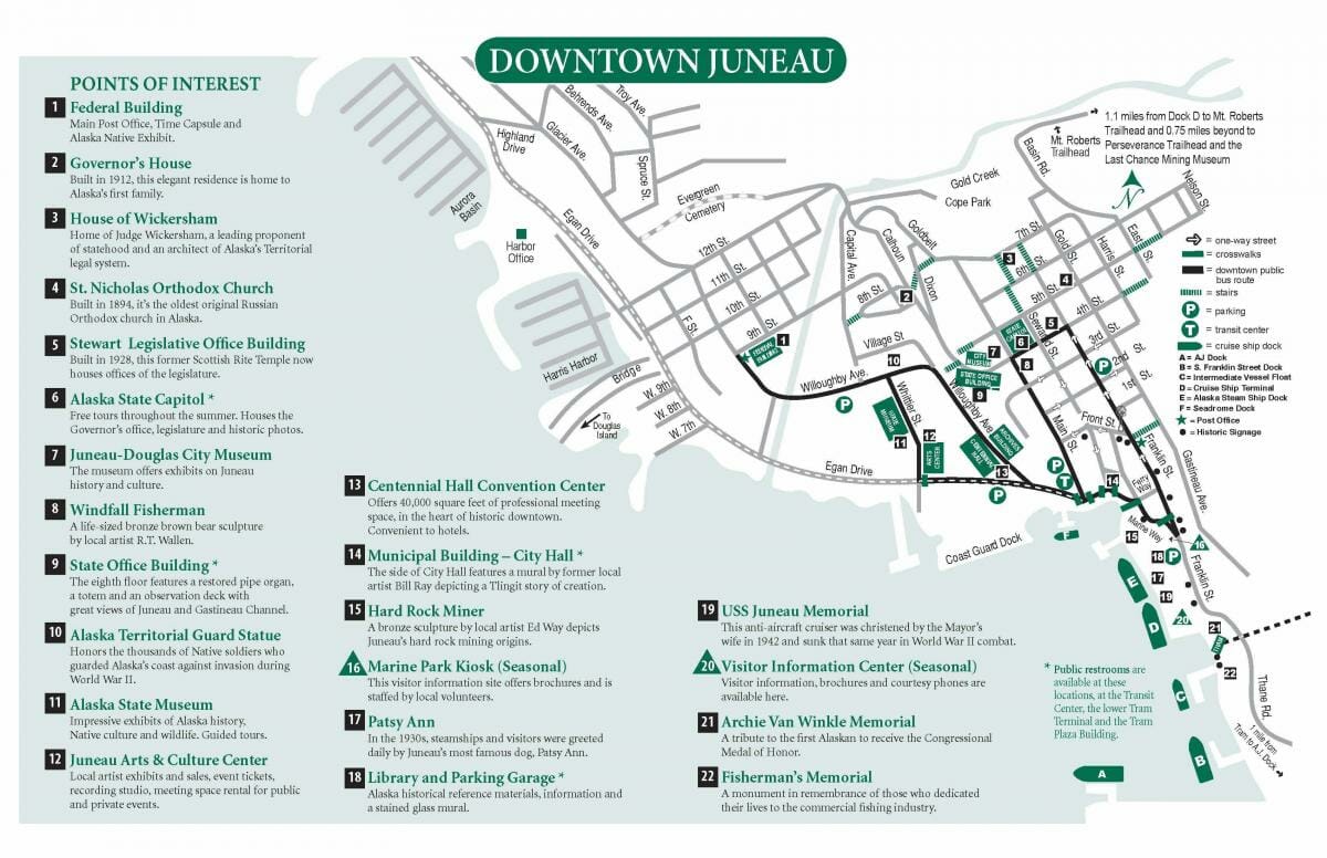
Printable Juneau Walking Map
According to Walk Friendly Communities Juneau has “impressive accessibility of facilities and excellent management of pedestrian facilities in a geographically constrained environment”. A comprehensive wayfinding system helps guide pedestrians around downtown Juneau and the City & Borough makes several historic and themed walking maps available to visitors and residents.
Hiking Trails
Drive
Driving in Juneau
There are no roads out of Juneau but many places to see within the miles road system. The longest road, Glacier Highway extends 40 miles north of downtown. The Alaska Marine Highway connects Juneau to Washington State, the northern areas of Alaska and neighboring Southeast communities.
Parking Downtown
Two hours of free on-street parking per day per vehicle is available in downtown Juneau. Instructions on how to get 2 hours of free on-street parking downtown are available here.
There are also two parking facilities located downtown:
- The Downtown Transportation Center Garage located at 100 Main Street
- The Marine Parking Garage located at 290 Marine Way below the downtown public library
Parking in both facilities is available on a first-come, first-served basis, and is metered during business hours (8:00am-6:00pm M-F). More information about the downtown parking facilities, including long-term permits, is available from the Department of Parks and Recreation here or by phone (907) 586-5226.
Explanation of Specific Driving Situations around Town
 HAWK Beacons
- Location(s):
- Mendenhall Loop Road at Floyd Dryden Middle School
- Near Wal-Mart on Glacier Highway
A High-Intensity Activated crossWalK pedestrian hybrid beacon, or HAWK beacon, is a traffic signal that allows pedestrians to cross streets more safely while causing less delay for motorists than standard traffic signals. There are two HAWK beacons in Juneau: oneon Mendenhall Loop Road at Floyd Dryden Middle School and one near Wal-Mart on Glacier Highway.
- A HAWK beacon remains dark until a pedestrian presses the call button, at which point the traffic signal illuminates a flashing yellow light followed by a solid yellow light, indicating to drivers to slow and stop if possible.
- Solid red lights appear after the solid yellow light and drivers are required to then stop.
- Next, the red lights begin flashing and drivers are allowed to proceed if the crosswalk is clear after coming to a complete stop.
More information about how HAWK beacons work is available from the Alaska Department of Transportation and Public Facilities here.
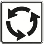 Roundabouts (map, info from DOT manual)
- Location(s):
- Douglas Highway at the Juneau-Douglas Bridge
- Downtown at convergence of Marine Way and Franklin Street
- Auke Bay at the convergence of the back Loop Road with Glacier Highway.
Roundabouts are circular intersections designed to make intersections safer and more efficient for drivers, pedestrians and bicyclists. Juneau saw the installation of the first roundabout in Alaska when the one downtown at the convergence of Marine Way and Franklin Street was completed in 2001. The roundabout on Douglas Highway at the Juneau-Douglas Bridge was completed in 2005. When using either roundabout in Juneau, drivers should follow these steps:
- Slow down as you approach the roundabout, and watch for pedestrians in the crosswalk.
- Continue toward the roundabout and look to your left as you near the yield sign and dashed yield line at the entrance to the roundabout. Yield to traffic already in the roundabout.
- Once you see a gap in traffic, enter the circle and proceed to your exit. If there is no traffic in the roundabout, you may enter without yielding.
- Look for pedestrians and use your turn signal before you exit, and make sure to stay in your lane as you navigate the roundabout. (Source: www.wsdot.wa.gov)
Right Turn Only Lanes and Bike Lanes
- Location(s):
- Glacier Highway at Anka Street in Lemon Creek
- (coming soon) Riverside Drive at Mendenhall Mall Road and Vintage Boulevard
There is one location in Juneau where a bike lane crosses the entrance to a right turn only lane: on Glacier Highway at Anka Street in Lemon Creek. The Department of Transportation and Public Facilities has plans to re-stripe where Riverside Drive intersects Mendenhall Mall Road and Vintage Boulevard. The design pictured below is the national standard and its use will increase in coming years until all bike lanes are striped this way at intersections.
When entering this right turn only lane, it is the responsibility of motorists to yield to any bicyclists that are proceeding through the intersection.