Flood Map Revisions
Project Contact Information
If you have questions, please contact CBJ Permit Center at 907.586.0770 or [email protected]
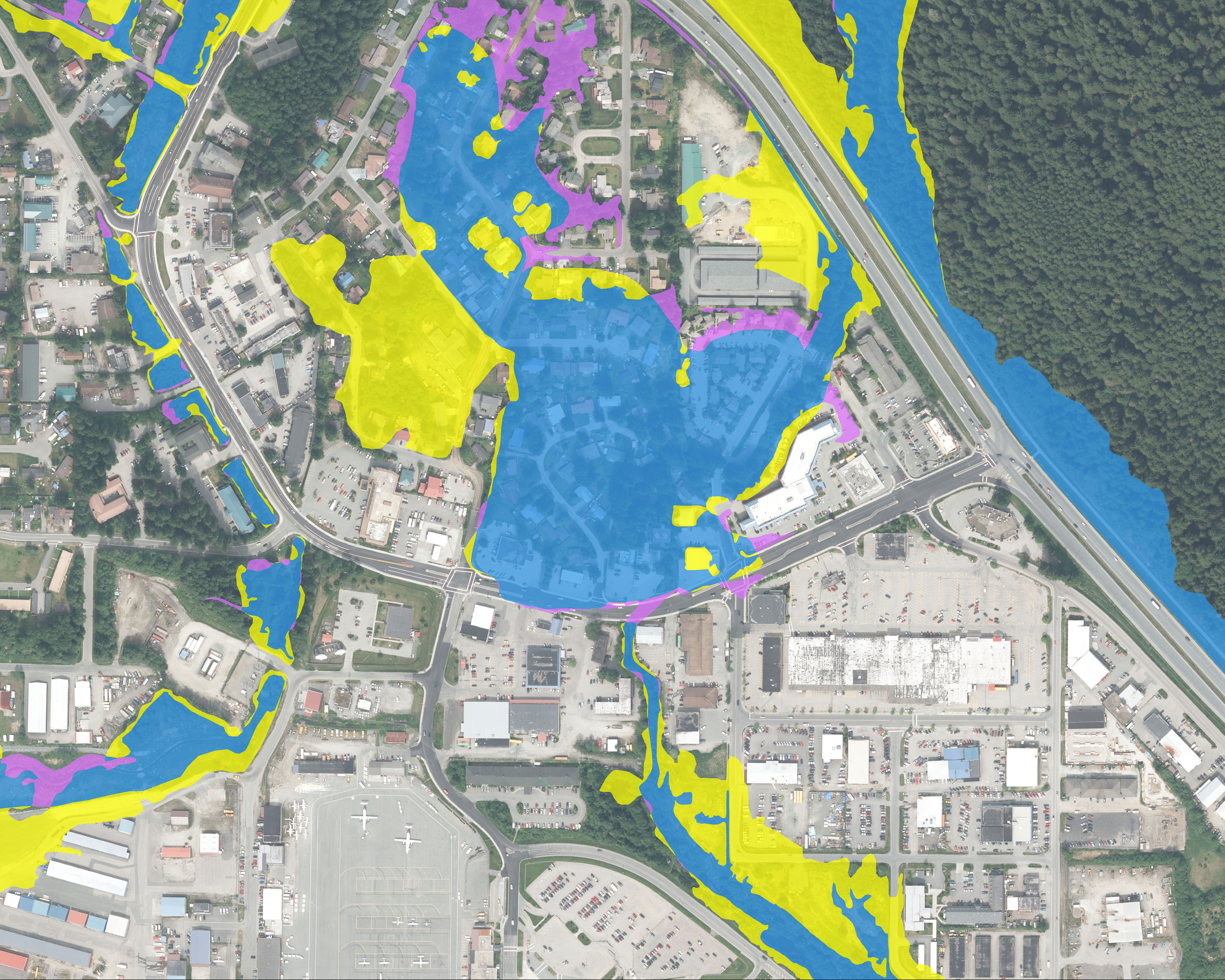
The City and Borough of Juneau (CBJ) and the Federal Emergency Management Agency (FEMA) recently completed an update of the borough-wide flood zone maps. The new Flood Insurance Rate Map is effective as of September 18, 2020. Flood zones are based on both scientific and community-provided data that helps identify areas with the potential for storm and flood events that may put lives and property in danger. Using recent topographical and engineering data, the CBJ has worked closely with FEMA to ensure the flood maps are as accurate as possible.
Updated maps will be used by community officials for future development, land use mapping, hazard mitigation planning, and implementation of the City’s flood management ordinance and policies. Map designations inform flood insurance rates for properties that have federally backed loans. Updated maps are a requirement for CBJ participation in FEMA’s National Flood Insurance Program.
Under the map revision, approximately 191 properties were removed from the Special Flood Hazard Area. Homes within the Special Flood Hazard Area are required to obtain flood insurance with a federally-backed mortgage. Approximately 45 properties were added to the Special Flood Hazard Area.
Final Borough-wide
Flood Map Adoption
Effective Flood Insurance Rate Map (FIRM)
Comparison of 2013 and 2020 FIRMs
CBJ Flood Insurance Study
As a result of public comments from the 2018 and 2019 public process, FEMA has released the final Flood Insurance Rate Map. The map link above provides a comparison between the previously adopted 2013 Flood Insurance Rate Map and the final revised map adopted September 18,2020. The final map and the CBJ Flood Insurance Study are also available through the FEMA Map Service Center at https://msc.fema.gov/portal/home. At this link, click “search all products,” enter state, enter Juneau Borough under “county,” enter City and Borough of Juneau for community, and click on “product.”
Tee Harbor Flood Maps
Final Flood Insurance Rate Map for Tee Harbor
Applicable area is along the Tee Harbor coastline and surrounding area. As a result of comments received in 2018, CBJ worked with FEMA to develop a precise study of the Tee Harbor area. This study has greatly improved the accuracy of the maps and will result in lower flood insurance rates for most homeowners. The Tee Harbor study and map revision has been completed through FEMA’s Letter of Map Revision process and is separate from the Borough-wide flood map revision process. The Tee Harbor Flood Map Revision is final and effective as of May 26, 2020. The map link above (coming soon) provides a comparison between the recently effective 2013 Flood Insurance Rate Map for Tee Harbor and the final effective map. The final map is also available through the FEMA Map Service Center at https://msc.fema.gov/portal/home. At this link, click “search all products,” enter state, enter Juneau Borough under “county,” enter City and Borough of Juneau for community, click on “effective products,” click on “LOMC,” then “LOMR,” then Product ID 19-10-1198P-020009.
Phase 1 | Discovery
2013 | The CBJ acquired grant funding from the Coastal Impact Assistance Program to collect improved aerial imagery and topographic mapping data (LiDAR – Light Detection and Ranging). The CBJ presented the new LiDAR data to FEMA as justification for why the current flood maps were inaccurate and a new new study was needed. These improved data-sets were not available for the study that produced the effective maps adopted in August 2013, but laid the groundwork for the more accurate revisions being made today.
Phase 2 | Preliminary Flood Insurance Rate Maps (FIRMs)
August 25, 2017 | Preliminary draft maps had a soft release and a detailed review was conducted by city officials.
January 9, 2019 | FEMA formally presented the study results at a Consultation Coordination Officer Meeting, and the draft maps were released publicly on the CBJ and FEMA’s websites.
April 4, 2018 | The CBJ and FEMA hosted an Open House for the community. Topics of discussion included:
- Background of the National Flood Insurance Program
- Flood Study Map Update Information
- The process and schedule for updating the Juneau flood maps
To see the information and presentations from the Open House, visit our meetings tab.
April – June 2018 | A 90 day appeal and comment period commenced, allowing the public to document concerns on the preliminary maps. Each comment that provided more precise technical or scientific data was evaluated in order to improve the accuracy of the maps.
Phase 3 | Additional Public Appeal and Comment Period
July 2018 – July 2019 | CBJ and FEMA reviewed the scientific and technical data received, and improved the accuracy of the flood maps.
July 24 – October 21, 2019 | A second 90-day public comment period commenced. This appeal/comment period addressed only the minor revisions depicted by the pink line referenced in the map link. This second round of changes is uniformly positive, due to an across-the-board reduction in the floodplain for the affected areas. The revision affects a sliver of coastline that is only 5′-10′ wide, from Lena Point to West Juneau, affecting approximately 400 parcels. Approximately 20 structures were removed from the flood zone.
August 28, 2019 | CBJ and FEMA hosted another Open House with presentations and information on the maps and what this means to the public.
August 29, 2019 | FEMA conducted a 3-hour surveyor training course on how to accurately complete FEMA elevation certificates.
FEMA spent the next 3-6 months reviewing the appeals/comments and incorporating them into their final determination.
Phase 4 | Adoption of Flood Insurance Rate Maps, Flood Insurance Study, and Flood Hazard Areas Ordinance
March 18, 2020 | CBJ received the Letter of Final Determination from FEMA, with the final pending Flood Insurance Rate Map and Flood Insurance Study.
June 23, 2020 | The CBJ Planning Commission will review these flood materials at the June 23, 2020 regular Planning Commission meeting.
September 18, 2020 | Federal regulations dictate that the maps will be effective exactly six months from the date of this letter, on September 18, 2020. Prior to this date the CBJ Assembly must adopt the map, study, and the flood hazard areas regulations by ordinance. Final Assembly hearing dates have not yet been determined.
Tuesday, June 23, 2020
Planning Commission Meeting
Zoom Webinar - See Agenda for Link
07:00 PM
Documents
Presentations
- No Presentations
Monday, June 01, 2020
Lands Committee
Zoom Webinar - See Agenda for Link
05:00 PM
Documents
Presentations
- No Presentations
Thursday, August 29, 2019
Surveyor Training
Assembly Chambers, City Hall
01:00 PM
Documents
FEMA Region X Regional Flood Insurance Liaison, Scott Van Hoff, will be conducting a 3-hour surveyor training course on how to accurately complete FEMA elevation certificates.
Presentations
- No Presentations
Wednesday, August 28, 2019
Open House
Dzantik'l Heeni Middle School Commons
06:00 PM
Documents
- Open House Agenda
CBJ welcomes FEMA representatives to inform the community on the most recent updates to flood maps and next steps.
Presentations
- No Presentations
Wednesday, April 04, 2018
Open House
Dzantik'l Heeni Middle School Commons
06:00 PM
Documents
Presentations
Comments
Below are ways to submit comments on the project:
Now through June 19, 2020 at noon | Email [email protected] for your comments to be seen by the Planning Commission/
June 23, 2020 at 7:00 p.m. | Present public testimony to the Planning Commission. Call in information can be found on the agenda.
After June 23, 2020 | Comments can be emailed to the Assembly at [email protected].
For questions about the project, contact:
CBJ Permit Center | 907.586.0770 | [email protected]
Public Noticing Efforts
As a local municipality, it is important to the CBJ to outreach the public as thoroughly and efficiently as possible. CDD holds itself to high standards regarding public outreach through inclusivity and community engagement, core values to our mission.
- Webpage with links on CDD homepage
- Webpage highlight on CBJ homepage prior to Open Houses
- Facebook notifications
- Press releases to media
- 1,755 physical mailings sent to all property owners within, or adjacent to, a flood zone to inform them of the project and the April 4, 2018 Open House
- April 2018 Open House Event – 160+ in attendance
- Responded to 150+ flood map inquiries
- Presentation to Realtors Association on May 8, 2018
- Article in City Corner on June 15, 2018
- Direct phone and email outreach to CBJ and State agencies
- Presentations to CBJ Planning Commission and Assembly
We are in the process of another large outreach for phase 3 of the project. Stay tuned for updates on these noticing efforts.

