
Parks and Rec Projects
Montana Creek Plan
Budget: N/A
Contractor:
Estimated Completion: 05/10/2023


Project Overview
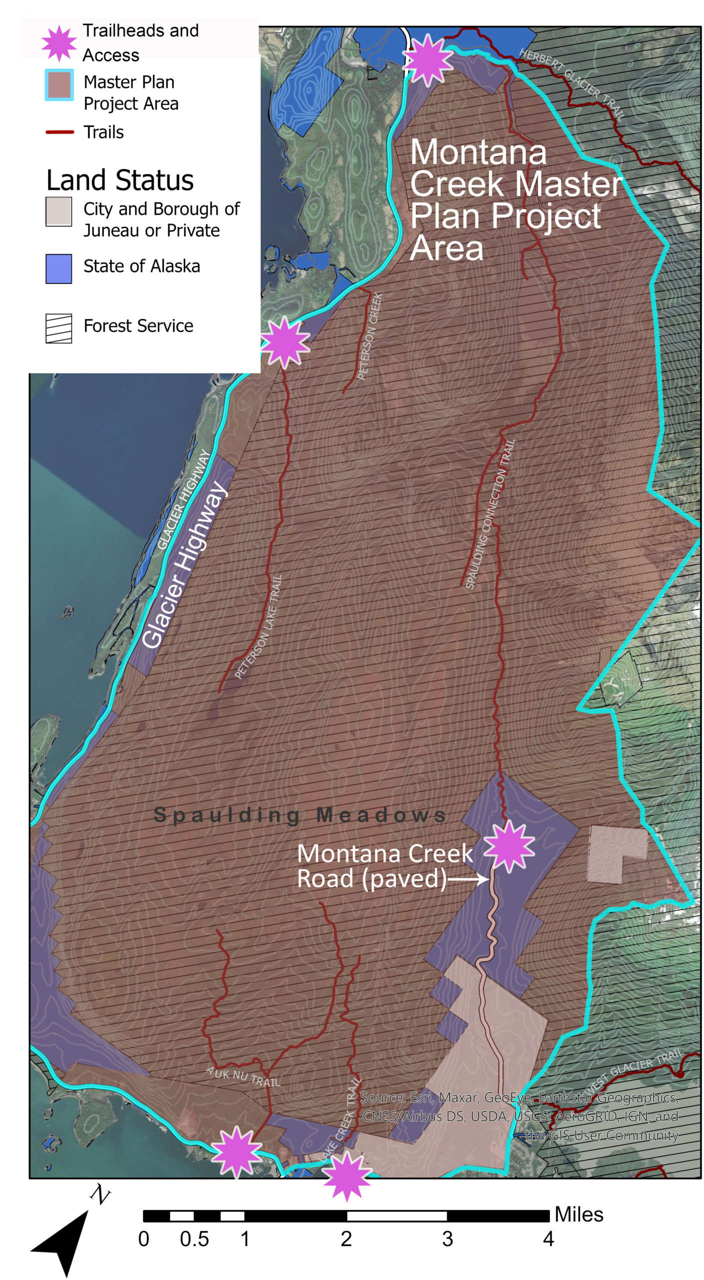
The Juneau community values the Montana Creek valley, watershed and surrounding areas for recreation and abundant natural resources. Fishing, hunting, snowmobiling, shooting sports, hiking, skiing, snowshoeing, four wheeling, camping, and subsistence harvesting are some of the recreational activities occurring in this area. In the summertime, Montana Creek is rich with fish species and the surrounding areas are wild. Despite the close proximity to the densely populated Mendenhall Valley, the area feels remote. In the winter, the area remains colder than some other parts of Juneau. Snow remains in the valley longer because of this and allows for winter sports at times when other parts of Juneau have thawed and do not have the snowpack to support these sports.
The Montana Creek Plan process seeks participation from land owners, user groups and the general public to understand current use of the area, existing plans and projects, proposed projects, ideas and concerns for recreational use of the area, impacts to natural resources, and current recreational uses. An interagency working group with the City and Borough of Juneau, United States Forest Service, Alaska Department of Natural Resources, the Alaska Department of Transportation and Public Facilities and Trail Mix facilitate the meetings and drafting of the plan with a ten year horizon.
Public outreach began in the summer of 2021 with an informal survey to better understand the current recreational uses, ideas for improvements, and community values for recreation in the project area. The results from the survey were used to develop and guide the public and plan process. In the fall of 2021, land managers met with stakeholder groups in the area to understand their goals and vision for the process and project area. Based on feedback from these meetings, an online GIS mapper was developed with existing resource data for the project area, motorized use regulation maps were developed, and existing community plans were gathered. Using this data and feedback from the survey, stakeholder meetings, and a stakeholder design charrette in spring of 2022, a draft infrastructure master plan was developed and presented to the public on August 10, 2022. The meeting was held on zoom and the CBJ Parks and Recreation Department, United States Forest Service Department of Natural Resources, Alaska Department of Transportation and Trail Mix presented the plan and asked for public comment. A second community meeting was held in person at the Trail Mix shop in Lemon Creek to review revisions to the plan on December 7, 2022. A public review period of the final draft was held in March 2023. Comments submitted by the public were reviewed and the plan was revised. The plan is now complete.
The Final Plan was presented to the public on Wednesday, May 31st at 5pm at the Trail Mix Shop, 5723 Concrete Way, Lemon Creek.
Email questions or comments to [email protected].
Thank you for your participation and input.
Montana Creek Plan Documents
- Final Montana Creek Plan May 2023
- Project Area Map
- Survey Report
- Existing Motorized Use Regulation Maps -Overland and Oversnow
- All Public Comments August 2022 to March 2023
- Baseline Data Map (Please review the how-to guide here)
Plan Drafts and Meetings
Associated Documents
- Parks & Recreation Master Plan 2019-2029 (CBJ Assembly Adopted Plan)
- Comprehensive Plan of the City & Borough of Juneau 2013 (CBJ Assembly Adopted Plan)
- Juneau Trails Plan 1993 (CBJ Assembly Adopted Plan)
- Juneau State Land Plan 1993
- Montana Creek Watershed Stewardship Plan 2014
- Montana Creek Lands Assessment and Recreation Corridor Conservation Proposal 2006
- Kaxdigoowu Héen Watershed Scoping 2010