
Hesco Barrier Phase 2
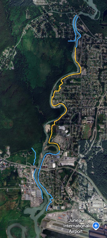
Yellow: HESCO Barriers Phase 1, Blue: HESCO Barriers Phase 2
Project Summary
Under U.S. Army Corps of Engineers (USACE) Advance Measures Assistance, the USACE in – partnership with CBJ – is moving forward with riverbank armoring and installation of temporary (HESCO) flood barriers along the remaining unprotected, populated riverbank areas of the Mendenhall River – referred to as Phase 2 – to construct a fortified, complete temporary flood barrier prior to July 15, 2026.
USACE contractor Sealaska Constructors is be leading the work, which beganwith bank armoring along Clinton Drive during the week of March 16 before moving to other unprotected areas of the river.
HESCO barrier installation, bank armoring and related work is ongoing. On June 5, a contract modification was awarded to Sealaska Corp. to construct an earthen berm extending about 1,100 feet east from the Back Loop Bridge. The berm will follow the general alignment of the existing high ground to provide flood protection for Back Loop Road and downstream portions of the community. Read the Joint Press Release.
The public is asked to avoid the construction area for their safety and the safety of workers, residents and property owners.
For more information about the Phase 1 HESCO barrier project installation, repairs and reinforcement, visit the project page.
Project Background
On September 19, 2025, the City and Borough of Juneau (CBJ) submitted a scope of work that the United States Army Corps of Engineers (USACE) has accepted to include (but not be limited to) for the ongoing evaluation, repair, and reinforcement of existing HESCO barriers and barrier sites, paid for with 100% Federal funds. USACE plans to complete this work no later than mid-July 2026.
On September 29, 2025, the CBJ Assembly Committee of the Whole discussed future developments and next steps in the HESCO barrier project, noting that paths forward will be informed by the actions and decisions made by USACE. Please see the full September 29 meeting materials, including a proposed phase 2 project map here.
The USACE accepted CBJ’s request for USACE Public Law 84-99 Advance Measures Assistance to protect against the increasing future glacial lake outburst floods. USACE will provide installation for Phase 2 flood barriers and technical assistance for Phase 1 repairs and reinforcement.
The City and Borough of Juneau (CBJ) formally accepted Advanced Measures Assistance offered by the United States Army Corps of Engineers (USACE) at the Special Assembly Committee of the Whole Meeting on October 30 (View meeting materials and recording).
The scope described below will be provided at by USACE at 100% Federal cost with no cost to the Public Sponsor (CBJ) and will be completed prior to July 15, 2026.
On February 11, 2026 USACE entered into a contract with Sealaska for this project.
CBJ is incredibly grateful to the ongoing partnership and support of the USACE and our local, state, tribal and federal delegations for their advocacy and facilitation of this critical assistance.
USACE Advance Measures Scope of Work
- PHASE 2 FLOOD BARRIERS: USACE will provide direct assistance by installing riverbank armoring and temporary flood barriers and other tasks necessary to construct a fortified, complete temporary flood barrier along the Phase 2 alignment for the imminent GLOF threat to the unprotected, populated riverbank areas of the Mendenhall River.
- This area includes:
- The continuation of barriers from the end of Phase 1, down river on the east bank through the Brotherhood Bridge;
- Both banks of the river from below Brotherhood Bridge to the river outlet past the Mendenhall Wastewater Treatment Plant;
- The west bank of the river north from Brotherhood bridge, along the Kaxdigoowu Heen Dei (trail) to higher ground above the Wildmeadow Lane neighborhood;
- The west bank from Back Loop Bridge extending downstream through the extents of the River Road neighborhood;
- The east bank from the Back Loop Bridge, extending downstream to connect to the beginning of Phase 1 at the north end of Marion Drive.
- This area includes:
-
-
- NEW(June 2026): On June 5, a contract modification was awarded to Sealaska Corp. to construct an earthen berm extending about 1,100 feet east from the Back Loop Bridge. The berm will follow the general alignment of the existing high ground to provide flood protection for Back Loop Road and downstream portions of the community. Specifically, the new infrastructure is designed to prevent overtopping on the road and is located on Forest Service managed land. Read the Joint Press Release.
-
-
- The work includes, but is not limited to, constructing and restoring access points for installation of bank armoring, temporary flood barriers and other necessary flood fighting infrastructure, culverts and check valves, and other tasks necessary to construct a fortified, complete temporary flood barrier such as site grading and foundation improvements.
- PHASE 1 FLOOD BARRIERS: USACE will provide technical assistance for the repairs, fortification, increasing the temporary flood barrier height, bank armoring and other associated items related to the Phase 1 temporary flood barrier installation to protect against the increasing future GLOF events to continue effectively providing temporary flood protection to the Phase 1 inundation area.
- Map at right shows damage and areas needing fortification, repairs and additional barriers following the 2025 GLOF.
")
Contact Us
- To comment, provide input, or for general project inquiries, please email [email protected]