CBJ Guide To Flood Preparedness

Aerial view of flood danger section of Mendenhall River

No Flooding Expected – Stay Informed and Monitor Conditions

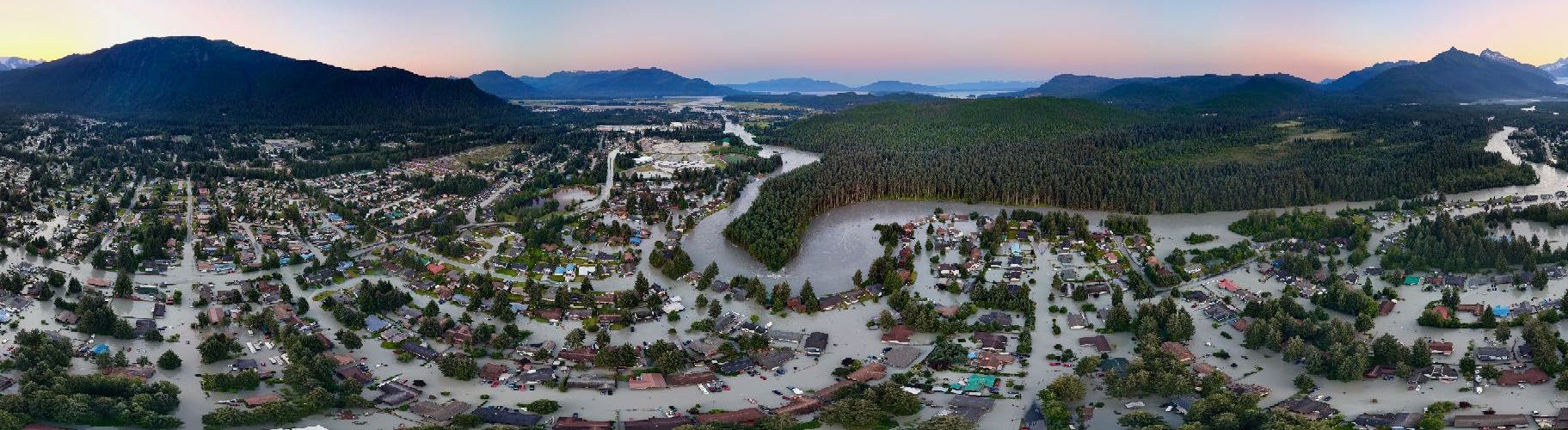
Based on current data, the risk to life and property from a Glacial Lake Outburst Flood (GLOF) remains low at this time. Monitoring will continue throughout the season.

Key Action Links

SIGN UP FOR EMERGENCY ALERTS
CURRENT SUICIDE BASIN CONDITIONS (NWS)
CURRENT MENDENHALL RIVER CONDITIONS (NWS)

How to Prepare for a Flood

What to do During a Flood

Before the Flood

  • Monitor alerts and news
  • Charge your phone and pack your go bag
  • Move valuables off the floor & take action to prevent spills

During the Flood

  • Follow evacuation orders
  • Shut off electricity if it’s safe
  • Don’t wait — water rises quickly
  • Do NOT walk or drive through flood waters

After the Flood

  • Return home only when cleared
  • Watch for mold, damage, and contamination
  • Visit bit.ly/JuneauFloodRecovery for clean-up and recovery resources

Sandbag Distribution

CBJ and Tlingit & Haida are partnering to host an additional sandbag distribution event to help residents prepare for potential flooding along the Mendenhall River.
Where: Dimond Park Field House (Parking area)
When: Saturday, July 26 – 11:00 a.m. – 3:00 p.m.

Emergency Shelter

Floyd Dryden Gymnasium (3800 Mendenhall Loop Rd) has been identified as the emergency evacuation shelter location in the event of a flood warning and evacuation notice.

The American Red Cross will operate the shelter. Check out these tips for how to prepare for an emergency in the video below

Capital Transit will assist with the transportation of evacuees from Riverview Senior Living and Trillium Landing to Red Cross Shelters as well as overflow shuttling from Floyd Dryden to contingency shelter locations if the primary shelter capacity is exceeded.

Juneau Glacial Flood Dashboard

The Juneau Glacial Flood Dashboard (JuneauFlood.com) is a comprehensive resource about glacial lake outburst floods (GLOFs) from Suicide Basin. Created and maintained by the University of Alaska Southeast in partnership with the Alaska Climate Adaptation Science Center,  the page provides an interactive view of the flood inundation maps, information about flood forecasting, history of past outburst flood events, and an of understanding of how outburst floods originate from Suicide Basin, including how they form, what triggers them, and how they can impact the Juneau area.

Vehicle Parking

Residents in the flood inundation area that (are not sheltering at Floyd Dryden) are invited to move vehicles (cars, ATVs, etc.) to the following parking lots once the Basin is full and evacuation preparedness alert is sent out:

  • St. Brendan’s Episcopal Church
    • 4207 Mendenhall Loop Road
  • Shepherd of the Valley Lutheran Church
    • 8198 Keegan Street
  • Christ Lutheran Church
    • 10300 Glacier Hwy
  • Juneau Christian Center
    • 8001 Glacier Hwy

Please register your vehicles here.

Evacuation Routes

To avoid congestion and road or bridge closures, please follow the evacuation routes below. 

  • Residents north of Division Street, please travel north on Riverside Drive, toward Mendenhall (Back) Loop Road and out of the inundation area.
  • Residents south of Division Street, travel south on Riverside Drive, turn left on Stephen Richards Memorial Drive, towards Mendenhall Loop Road.
  • On Rivercourt Way, travel south on Riverside Drive, toward Egan Drive
  • On the west side of the Mendenhall River, travel west on Mendenhall (Back) Loop Road toward Auke Bay (avoid Back Loop Bridge).
  • West of Brotherhood Bridge, travel west on Glacier Highway toward Auke Bay

Route Maps

Evacuating With Pets

While the Red Cross is not able to accommodate pets at the Floyd Dryden Shelter, Juneau Animal Rescue (JAR) offers emergency sheltering for pets through their Safe-Keeping Program (PDF).

JAR and KTOO have created resources to help pet owners prepare for emergencies and evacuation. Click the button below to watch the video or download JAR’s Emergency Pet Planning brochure.

Learn more here. 

Road Closure Info – Alaska 511

Alaska DOT and CBJ will be tracking and reporting road closures at 511.alaska.gov.

You can sign up to receive alerts and visit the Alaska 511 website for the latest road closure updates.

River Cams

Follow live camera footage of Mendenhall Lake and Mendenhall River:

Volunteer/Ask For Help

The United Way of Southeast Alaska is coordinating volunteer efforts and offers of help. Sign up to volunteeror ask for help here. 

National Weather Service

Alaska DEC – Spill Response

Tlingit & Haida Emergency Services

University of Alaska Southeast

American Red Cross – Alaska

Contact Us