
Urban Avalanche Advisory
Current Advisory as of
January 16, 2026
Expires 7:00 AM the following morning.
Issued By John Bressette
Today's Discussion
Temps are on the rise this morning with the tram already above freezing and top of eaglecrest at 32 F. Don't expect to see much activity today but we could see some small slides with rising temps and the NWS talking about possible inversions with higher temps at elevation than at sea level. We were unable to do lidar yesterday but it is still lined up and we are ready to jump on any adequate weather window hopefully combined with fieldwork with assistance from the AELP crew.
Primary Avalanche Problem
Wet Slab
Description
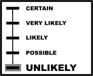
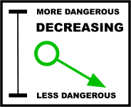
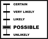
Wet slabs remain on our problem list but the likelihood is decreasing as we have not seen any activity in many days.
Learn more about Wet Slab.Secondary Avalanche Problem
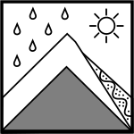
Loose Wet
Description
We could see some smaller loose wet activity but should not be anything that threatens infrastructure.
Learn more about Loose Wet.Today’s Avalanche Tip
I don't think we necessarily need a new snow discussion to go out to the public but am happy to write something up if either of you feel differently. A few things I think we should consider doing are changing our wording so that we are maybe back down to ready, putting out some images showing how close some of the debris came to homes to help explain the evac. advisory, and an official thank you to AKDOT&PF, the NWS and AELP.